
Goulburn River / River management
Understanding Goulburn River Levels
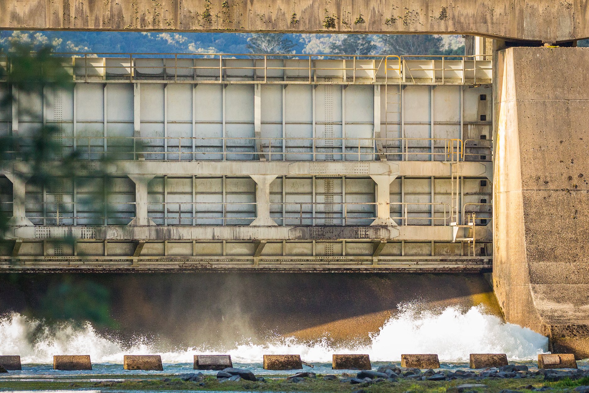
How Lake Eildon, irrigation, environmental water and changing releases shape the trout river below the dam.
I first wrote this article nearly twenty years ago. Much of what anglers see on the river remains familiar, but the way the system is managed, and the information now available to us, has changed considerably.
I first wrote a version of this article nearly twenty years ago. At the time, explaining the Goulburn to anglers was relatively straightforward. Lake Eildon stored water, irrigators ordered it, Goulburn-Murray Water released it, and the trout river below the dam rose and fell accordingly. That explanation was never completely wrong, but it is no longer adequate. The way the system is managed, the role of environmental water, the rules surrounding water traded between the Goulburn and Murray systems, the information now made available to the public and our understanding of the ecological consequences of different flow regimes have all moved considerably since then.
The questions anglers ask, however, have hardly changed. Someone rings and says the river is running at 1,500 ML/day and wants to know whether that is high or low. Someone else sees that the release is going to 4,000 and assumes the fishing is ruined. Another angler has been watching the river for three days, notices it is falling and wants to know whether that will improve the hatch. Increasingly, people also see announcements about environmental flows, inter-valley transfers or a 9,000 ML/day target at Murchison and understandably wonder whether that means the same amount of water is about to come past Thornton.
The first thing to understand is that there is no single river level that tells you whether the Goulburn will fish well. A flow of 2,000 ML/day can be excellent. So can 6,000. We have had very good fishing at considerably more than that and ordinary fishing at levels most anglers would describe as perfect. The number matters, but it is only the beginning. What the river has been doing before it reaches that number, how quickly it got there, whether it is still rising or falling, the water temperature, clarity, weather, insect activity and where the trout have moved all matter just as much. A stable river at 2,000 ML/day can fish quite differently from one that has just fallen rapidly from 5,000, and both can be very different from a river rising through 2,000 on its way to something much higher.
Reading the river
Start with the number, but do not stop there
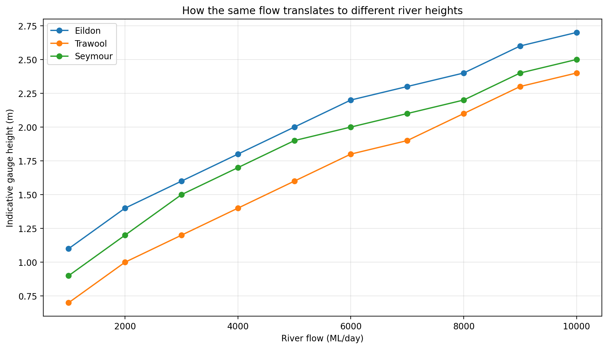
River flows on the Goulburn are usually discussed in megalitres per day, abbreviated to ML/day. One megalitre is one million litres, so a flow of 2,000 ML/day represents two billion litres moving through the system over twenty-four hours. It sounds enormous, but the number by itself still does not tell you how deep the river will be where you are standing. The shape of the river channel changes continuously, so the same discharge produces different gauge heights at different locations.
Goulburn-Murray Water’s own indicative figures demonstrate this neatly. At 5,000 ML/day, the gauge height is approximately 2.0 metres at Eildon, 1.6 metres at Trawool and 1.9 metres at Seymour. At 10,000 ML/day the corresponding indicative figures are around 2.7, 2.4 and 2.5 metres. Those are gauge heights relative to the local gauge datum, not the depth of water under your boots. They are useful because they show why saying the river is “two metres high” without naming the gauge is almost meaningless.
The picture becomes more complicated as you travel downstream. Lake Eildon controls the largest single input into the upper regulated river, but it does not control every litre that passes Alexandra, Trawool or Seymour. The Rubicon, Acheron, Yea and numerous smaller tributaries enter below the dam. After widespread rain, the amount of water passing downstream gauges can therefore differ substantially from the amount released from Lake Eildon. This distinction is one of the reasons we now separate Lake Eildon release from observed river flow in our fishing reports. They may be similar on a dry day near Eildon, but they are not the same measurement.
A regulated tailwater
Why the Goulburn behaves backwards
To understand the trout river, it helps to forget for a moment what a Victorian river is supposed to do naturally. An unregulated stream in this part of the state would generally carry more water through the wetter winter and spring months, then decline as summer becomes warmer and drier. The Goulburn below Lake Eildon often does almost the reverse. Water is stored through the cooler months and released as demand increases through spring and summer, producing the familiar high, cold river that anglers see during the irrigation season.
That reversal is one of the defining features of the fishery. In January, many smaller streams across central and north-eastern Victoria are becoming low and warm. The Goulburn may instead be carrying thousands of megalitres of cold water each day, much of it drawn from depth within Lake Eildon. To someone accustomed to conventional trout streams, a summer Goulburn running at 7,000 or 8,000 ML/day can look absurdly high. The temptation is to stand on a bridge, see the water pushing against the willows and conclude that the river is unfishable. The trout do not share that view. They simply occupy a different part of the river.
At low flows, many fish hold in the obvious places: seams, riffles, heads and tails of pools, drop-offs and well-defined runs. Increase the river several thousand megalitres and some of those places disappear beneath much deeper water, while entirely new habitat becomes available along the margins. Depressions in the bank become backwaters. Grass that was dry two days earlier is submerged. Willow roots, side channels and soft edges become feeding water. The river has not necessarily become worse. It has changed shape, and the angler has to change with it. This is also the great advantage of the Goulburn as a trout fishery. The same releases that make it look intimidating in summer help keep the water comparatively cool.
Lake Eildon
What the storage is actually managed for
It is common to hear Lake Eildon described simply as an irrigation storage. Agriculture is unquestionably one of the major reasons the reservoir and regulated river exist in their present form, but the modern system is considerably more complicated. Water stored in Eildon supports irrigated agriculture, towns and businesses, domestic and stock needs, environmental entitlements, transfers between river systems and a variety of other authorised uses. Goulburn-Murray Water is the storage manager, operating within the bulk entitlement and the rules governing how water is harvested, stored and supplied.
That is worth keeping in mind whenever anglers are frustrated by a river movement. GMW is not selecting a flow to optimise a Saturday afternoon mayfly hatch, nor is it generally moving the river simply because somebody decided that 4,000 ML/day would be preferable to 2,000. Releases are part of a much larger operating system involving water orders, storage levels, inflows, forecast weather, downstream conditions, environmental requirements, inter-valley commitments and power generation opportunities associated with the broader release task.
Lake Eildon also cannot simply be kept as full as possible until somebody asks for water. Since 1959 the storage has operated with winter and spring filling targets. The present filling curve has been in use since 2012 and is designed around filling the storage in 19 years out of 20 under the assumed inflow conditions. The objective is primarily to protect the reliability of water entitlements while retaining some capacity to mitigate floods where circumstances allow.
This became a major public issue after the October 2022 floods. It is understandable that people downstream asked why the lake had not simply been kept lower. The subsequent technical assessment commissioned by the Victorian Government looked at alternatives ranging from lower target storage levels to rainfall-based pre-releases and changes to the filling curve. The conclusion was not that flood mitigation is irrelevant. Lake Eildon clearly provides substantial flood attenuation when storage space is available. In October 2022, inflows peaked at about 145,000 ML/day while peak releases were held to about 38,000 ML/day. The lake absorbed an enormous volume of water.
The difficulty is that Eildon is not a dedicated flood-control reservoir. Holding it permanently lower would reduce water-supply reliability and impose very large costs, while the flood benefits diminish downstream because tributaries below Eildon increasingly determine what happens at places such as Molesworth and Seymour. The 2024 assessment found no alternative operating arrangement that delivered sufficient flood-mitigation benefit to justify the wider costs and impacts.
In ordinary years, GMW therefore continues to work with filling targets, monitoring storage level, catchment wetness, expected inflows, forecasts and expected demand. The targets generally operate from May through October, although the final filling period can extend into November in wet years. Most ordinary releases leave Lake Eildon through the hydro-electric power station. Power generation can influence timing, but it would be misleading to imagine the river simply being raised or lowered for electricity production independently of the wider water-management task.
Mid and lower river
There are really two Goulburns in this discussion
One of the most important updates to the old version of this article is the need to distinguish between the mid-Goulburn, from Lake Eildon downstream to Goulburn Weir, and the lower Goulburn, below Goulburn Weir towards the Murray. The trout water most of our clients know around Eildon, Thornton and Alexandra sits in the mid-Goulburn. Many of the newer rules people encounter online, particularly those involving inter-valley trade, are specifically concerned with the lower river.
That distinction matters because the ecological problems are different. The mid-Goulburn is heavily influenced by releases from Lake Eildon and experiences the reversed seasonal pattern described earlier. The lower Goulburn has also had to cope with large volumes of water being moved towards the Murray, particularly during summer and autumn. As trade between the Goulburn and Murray systems expanded, the lower river was increasingly being used as a delivery channel for water that had effectively been transferred out of the Goulburn system.
For a time this created prolonged high summer flows downstream of Goulburn Weir. The environmental consequences included bank erosion, loss of riparian vegetation and changes to habitat along a river that naturally would have spent much more time at lower levels during the warmer months. Scientific work and environmental monitoring increasingly showed that the problem was not simply the peak flow. The lack of variation mattered as well. Holding the river unnaturally high for extended periods gave the banks little opportunity to dry, stabilise and revegetate.
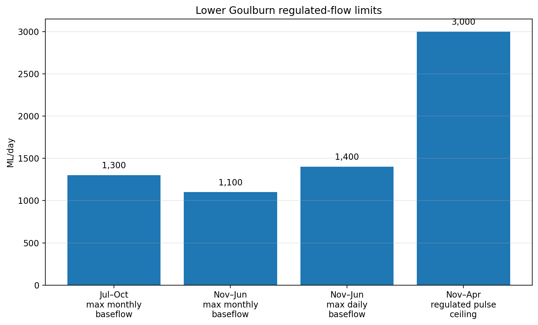
That led to a substantial change in the way inter-valley trade deliveries are managed. Long-term operating rules for the lower Goulburn commenced on 1 July 2022 and were incorporated into the Eildon-Goulburn Weir bulk entitlement. They work alongside the Goulburn-to-Murray trade rules to limit how much regulated water can be pushed through the lower river and, importantly, to ensure periods of lower flow between larger delivery events. For an angler, the principle matters more than the paperwork: a healthy river does not simply need more water. It needs variation.
Environmental water
Environmental flows are now part of normal river management
When the original article was written, anglers often spoke about environmental flows almost as though they were an occasional special release added on top of the “real” business of supplying water. That is no longer a useful way to think about the system. Environmental water is held under formal entitlements and is planned and delivered as an established part of river management.
The Victorian Environmental Water Holder publishes a Seasonal Watering Plan, while the Goulburn Broken Catchment Management Authority develops watering proposals for different reaches. Those plans are not simply about putting as much water as possible into the river. They are intended to reproduce particular components of a more natural flow regime where the regulated system allows it: low flows, freshes, larger pulses and connections to habitats that would otherwise become disconnected.
Immediately below Lake Eildon, in Reach 1, current environmental planning identifies a year-round low-flow range of approximately 400 to 2,000 ML/day. Within that range, the objectives include maintaining habitat for small native fish, platypus, turtles, waterbugs and aquatic vegetation. Flows above about 800 ML/day can bring additional benefits such as scouring fine sediment from gravel and maintaining connections with low-lying off-stream habitat.
Those figures need to be interpreted carefully. An environmental recommendation of 400–2,000 ML/day does not mean that 400 is the legal minimum in every circumstance, and it certainly does not mean that 400 is the ideal flow for trout fishing. Passing-flow obligations, environmental objectives and good fishing conditions are three related but different questions. During the irrigation season, releases through the mid-Goulburn are often already well above many environmental low-flow targets because so much water is being moved for other purposes. At other times, environmental managers may take advantage of water already moving through the system, so a particular flow may be satisfying several objectives at once.
From an angler’s perspective
What all of this means for trout fishing
After more than thirty years working on the Goulburn, I have become less inclined to nominate a perfect river level. I certainly have levels I prefer for particular styles of fishing, and there are flows at which access becomes much easier or much harder. But there is an enormous difference between saying, “I like the river around 1,500 ML/day,” and saying, “The Goulburn only fishes well at 1,500.” The second statement simply is not true.
Below about 1,000 ML/day
Below roughly 1,000 ML/day, the Goulburn is genuinely low. Large areas of gravel and structure are exposed, bank access improves dramatically and wading becomes possible in places that disappear beneath summer releases. There is less water between the angler and the fish, which sounds ideal, but low water also removes much of the trout’s security. Fish can become extremely wary, occupy very specific lies and react badly to careless wading or poor presentation. Long leaders, stealth and accurate casts become increasingly important. In visual terms, the river begins to resemble the conventional trout stream most anglers expect, but that does not automatically make the trout easier.
Around 1,000–2,500 ML/day
Between roughly 1,000 and 2,500 ML/day, much of the traditional structure remains obvious. Riffles, seams, gravel bars, drop-offs and pool edges are relatively easy to read, while there is enough water to create good holding habitat throughout the river. Bank fishing and drift boating can both be effective, depending on the precise level and reach. For somebody learning the Goulburn, this range is often particularly useful because the structure remains legible. You can look at the surface and make a reasonable prediction about where a fish ought to be.
Around 2,500–5,000 ML/day
From about 2,500 through 5,000 ML/day, the river begins changing more obviously. Some low-water gravel disappears, familiar seams shift and the edges take on greater importance. New lies form against vegetation and along softer margins. Drift boats become increasingly useful because they allow anglers to cover long reaches while accessing water that is becoming awkward from the bank. This is often where people unfamiliar with the river begin describing it as high, while guides who know it simply start looking somewhere else.
Around 5,000–8,000 ML/day
Once the river moves into the 5,000 to 8,000 ML/day range, it is behaving like a proper summer tailwater. Wading opportunities diminish markedly, many gravel bars disappear and the river pushes into bankside depressions, willow edges, side channels and backwaters. Trout may sit surprisingly close to the bank, often in water that did not exist as habitat at lower flows. This is also the period when terrestrial fishing can become such an important part of the Goulburn. Beetles, ants, grasshoppers, cicadas and willow grubs all become relevant as the season progresses, and high water brings fish into direct contact with the margins from which much of that food originates.
Above about 8,000 ML/day
Above about 8,000 ML/day, access and safety become increasingly significant considerations. The river bears little resemblance to its winter form and bank fishing options become restricted. That does not mean the trout have stopped feeding. At the right time of year, flooded margins and soft edges can still produce excellent opportunities. The difficulty is increasingly one of reaching those fish safely and presenting a fly effectively. That is one of the reasons drift boats became so fundamental to the way we fish the Goulburn. The most important qualification to every one of those ranges is that direction matters. If someone tells me the river is at 3,000 ML/day, one of the first things I want to know is what it was doing yesterday.
Movement matters
Rising and falling water
A moderate rise can be very good. As water pushes onto previously dry ground, new edge habitat appears, aquatic insects can be dislodged, terrestrials are drowned and trout begin exploring lies that may not have existed the day before. A river rising steadily from 1,500 to 3,000 ML/day can therefore become more interesting rather than less, particularly once the fish adjust to the new level.
The difficult periods tend to be associated with rapid change rather than simply high water. A sharp rise can lift leaves, grass, twigs and other material from the banks, temporarily reduce clarity and force fish to relocate quickly. If tributaries are carrying colour, the lower reaches can change quite differently from the water immediately below Eildon. Yet even then, once the river stabilises, the fishing can improve surprisingly quickly. That is why we are reluctant to write off an entire day simply because GMW is increasing releases.
Rapid falls can be equally disruptive and, in some circumstances, more so. A trout that has spent several days feeding along a flooded willow edge or in a bankside depression may find that habitat disappearing beneath it. Large numbers of fish can be redistributing themselves at the same time, competing for a new set of feeding and resting lies. The river can briefly feel empty even though the trout obviously have not gone anywhere. Falling water can also be very good. After a prolonged period of higher flow, a recession can concentrate both fish and food. Invertebrates and other organisms using inundated margins are pushed back towards the main channel, and trout can respond quickly.
The same caution applies to hatches. I would no longer say that lowering the river directly causes a mayfly or caddis hatch. Insect activity is influenced by water temperature, light, season, life cycle and other biological factors. What we have seen repeatedly, however, is that large flow movements can alter insect drift and trout behaviour. Changing depth changes light penetration. Rising water inundates new ground. Falling water exposes it. Insects can be physically dislodged, temperatures can shift and the amount of food travelling in the current can change. Flow is part of the picture, but rarely the whole explanation.
Do not forget temperature
Water temperature deserves at least as much attention as the flow number. The Goulburn’s great strength as a trout river is that it is a cold-water tailwater. A visually attractive low river is not automatically superior to a large summer river if the larger release is keeping the water cool, oxygenated and biologically active. Conversely, anglers can become so focused on ML/day that they overlook temperature and dissolved oxygen, which often tell us at least as much about the quality of the water the trout are living in.
Putting it together
Release, gauge and where you are on the river
One of the changes we have made to our fishing reports is to distinguish more carefully between a published Lake Eildon release and an observed gauge flow. If GMW says tomorrow’s release will be 3,000 ML/day, that is the amount it plans to pass from the storage. The gauge tells us what is actually moving past that measuring point. Those values may be close, but they are not conceptually interchangeable.
The distinction becomes increasingly important downstream. Rain in the Rubicon, Acheron, Yea and other tributaries can add a great deal of water below Eildon. A storm can therefore leave the upper river comparatively clear and controlled while water farther downstream is rising and colouring. The reverse can also occur as a tributary pulse moves through and recedes. Timing matters as well. A release change begins at Eildon and its effect moves downstream. Thornton responds before Trawool or Seymour has fully adjusted.
This is important for guiding. The question is not always, “Is the Goulburn good today?” It can be, “Which part of the Goulburn is at the useful stage of the change today?” That is a much more productive way to think about a regulated river.
Wading
There is no universal safe wading threshold. The current, depth and riverbed vary too much from one location to another. As a broad practical observation, considerably more water becomes accessible to competent wading anglers as flows fall below roughly 2,000 ML/day, and many more options appear again below 1,000. That is not an invitation to assume every crossing is safe. The Goulburn remains a large river when it is low, and local depth and velocity always matter more than a single gauge number.
Drift boating
Drift boating works in almost the opposite way. The boat allows us to take advantage of flows that dramatically restrict bank access. Levels from around 1,000 through 8,000 ML/day can provide excellent boat fishing, and higher flows can still be productive when conditions, visibility and the particular reach are suitable. We do not decide whether to launch by looking at one number. We look at where the river is going, how much debris is moving, water clarity, weather, wind and what we have been seeing on the previous days.
Forecast releases
That broader view is why the short-term GMW release forecast has become so useful. It tells us not merely tomorrow’s expected number, but the intended direction of the river. If releases are forecast to move 1,500, 2,000, 2,500 and then 3,000 ML/day, we can begin thinking about the river as a transition rather than four unrelated figures. The forecast is still only a forecast. GMW explicitly warns that planned releases can change in response to inflows, rainfall, forecasts, customer requirements and operating conditions. That is not a flaw in the information. It is simply the reality of managing a large water system.
How to read a Goulburn announcement without becoming hopelessly confused
The easiest rule is to look at the location before looking at the number. A Lake Eildon release refers to water leaving the storage. A flow quoted for Trawool or Seymour is an observed or projected condition farther downstream. A target at Murchison may be associated with lower-Goulburn environmental operations or water passing Goulburn Weir. Those numbers should not automatically be treated as though they describe the same part of the river.
For a trout angler fishing Eildon to Alexandra, I would concentrate first on the Lake Eildon release, the actual Eildon gauge, recent tributary rainfall and what the river has been doing over the previous day or two. Everything else adds context.
So when should you come fishing?
Whenever you can
Geoff Hall used to give callers a wonderfully irritating answer when they asked this question: whenever you can. When I was younger, I thought that was hopeless advice. I wanted the flow, the forecast, the air pressure, the expected hatch and preferably some advance notice of what the trout intended doing at 2.30 that afternoon. After another couple of decades on the river, I have reluctantly concluded that Geoff was largely right.
That does not mean conditions are irrelevant. We look at them every day. Before guiding, we check the GMW release outlook, actual gauge movement, water temperature, rainfall, wind and weather. We compare those things with what we saw yesterday. If the river is changing, we think about where that change will have reached by the time we launch. If tributaries have risen, we think about how far downstream the colour has travelled. All of that information is useful.
It is simply not certainty. Some of the best days we have had on the Goulburn have occurred when one of the supposedly essential ingredients was wrong. We have also had beautifully stable rivers, warm overcast weather and an apparently perfect hatch forecast produce very little. The value of understanding river management is not that it allows us to predict trout perfectly. It allows us to arrive with a much better idea of what the river is doing, where the opportunities are likely to have shifted and what we should try first.
That is also the thinking behind the way we now build our fishing reports. We show what the river has actually done, rather than only quoting today’s number. We show GMW’s forward release plan so anglers can see whether it is expected to rise, fall or stabilise. We add Bureau of Meteorology weather and wind, and then combine that information with what our guides are actually seeing: clarity, water temperature, insect activity, rising fish and the parts of the day that have been most productive. The data matters, but the last part remains the most valuable. A gauge can tell you the river was running at 1,800 ML/day yesterday afternoon. It cannot tell you there were eight trout rising in one backwater, that the duns appeared every time a cloud crossed the sun, or that a brown moved five feet out from beneath a willow to eat a dry fly.
The short version
The number is useful. The story around it matters more.
If there is one conclusion to take from all of this, it is that the Goulburn cannot be reduced to a preferred number. Low water is not automatically good and high water is not automatically bad. A Lake Eildon release is not necessarily the same thing as the flow you will encounter farther downstream. The upper and lower Goulburn operate under different constraints, and announcements relating to one should not automatically be applied to the other.
Most importantly, a changing river can matter more than the absolute flow. Knowing that the river is at 3,000 ML/day is useful. Knowing that it was 1,500 two days ago, is still rising, has seven feet of visibility and produced duns under cloud yesterday afternoon tells you much more.
The trout are remarkably good at adapting to the Goulburn. Most of the difficulty lies in anglers expecting the river to stay the same.
Anthony Boliancu
Goulburn Valley Fly Fishing Centre